The goal of this project is to bring new features and functionality to Flomosys, the Flood Monitoring System of Silicon Valley. Flomosys 2.0 will implement multi-client support, dynamic frequency scaling, an overhauled web UI, and a novel low-power security algorithm.
You can find more details at this link:
Flomosys 2.0
The expansion of the Internet of Things (IoT) has led to numerous innovations in the industry, including improvements to existing systems. Disaster prevention and monitoring systems are prime examples of such systems. Every year, there are significant and preventable financial losses, not to mention the safety hazards caused by floods. To warn people ahead of time, we can deploy low-power wireless sensor nodes to send readings across any terrain to a cloud platform, which can perform pattern analysis, prediction, and alert forwarding to anyone’s cellular device. In this paper, we propose Flomosys, a low-cost, low-power, secure, scalable, reliable, and extensible IoT system for monitoring creek and river water levels. Although there are multiple competing solutions to help mitigate this problem, Flomosys fills a niche not covered by existing solutions. Flomosys can be built inexpensively with off-the-shelf components and scales across vast territories at a low cost per sensor node. In this paper, we present the design and implementation of this system as well as real-world test results. Index Terms—Disaster Monitoring, IoT, Wireless Communication, Security.
Current flood monitoring systems deployed worldwide have provided us with information on what methods work when developing a reliable, feasible, and sustainable solution. The Philippines, which is among the most flood-prone regions globally, has launched a program that predominantly utilizes Light Detection and Ranging (LIDAR) 3D terrain mapping and ultrasonic sensors. The LIDAR technology is coupled with computer-assisted analyses to pinpoint landslide-prone areas, while the ultrasonic sensors are utilized to monitor water levels. More recently, there has been an increased focus on deploying flood warning systems on urban streets. All of these sensors provide data that is analyzed and interpreted, then shared with the public via online flood information websites and mobile device applications.
Another organization in the Philippines developed a real-time flood monitoring and early warning system to monitor the Cagayan River’s water level using ultrasonic sensors. This sensor system consists of an Arduino, ultrasonic sensors, a GSM module, web-monitoring software, and SMS notification hooks to alert stakeholders and mitigate casualties related to flooding. In 2008, various states in the United States experienced devastating floods, including Iowa. This led the University of Iowa to create an Iowa Flood Center (IFC), which was also supported by the Tech State of Iowa. IFC has developed many inexpensive river stage2 sensors mounted on bridges to span rivers and streams. They have developed a self-contained and compact Bridge-Mounted River Stage Sensor (BMRSS) for monitoring small rivers and streams, consisting of an ultrasonic distance sensor, a solar panel, a GPS antenna, a cellular modem antenna, and a serial port. In operation, a BMRSS wakes periodically, measures its distance from the water surface, and transmits this information via the Internet to IFC servers.
BMRSS unit consists of an ultrasonic distance sensor from Senix, designed for operation up to 15.2 m, and supporting the RS-485 interfaces. BMRSS enhances the output from flood forecasting models and can operate for several years unattended, even in harsh environments. The flood monitoring system uses the Blynk platform as a medium of data transmission. This system uses two WiFi-based NodeMCU development boards connected through Blynk, a platform with iOS and Android applications to control an Arduino or RPi remotely via the internet. This platform provides a digital dashboard to build a graphical user interface with custom widgets. One NodeMCU is placed in the flood area while the second one acts as the control unit. The transmitter unit consists of a NodeMCU, an ultrasonic sensor, and a display to show the current reading. The ultrasonic sensor data is sent to the Blynk application over WiFi, where it is stored in a database and can be transmitted to the internet if the second NodeMCU is connected. This system provides a short communication range, especially in urban areas, and deploying nodes on many bridges would require full sets of hardware at each installation.
The major requirements of the system are reliability, energy efficiency, scalability, and security. Concerning reliability, in the case of system failures, flood warnings may not reach endangered communities, which is arguably worse than having no system in place at all, as residents may rely on the system. Reliability must be addressed from multiple perspectives. First, the sampled data regarding water height must be accurate. Second, the software managing the operation of Nodes, Gateway, and Cloud platforms must be bug-free and always be operational. Third, the Nodes must be able to transmit their data to the Gateway reliably. Fourth, the lifetime of the system components—especially the battery— must be long and predictable.
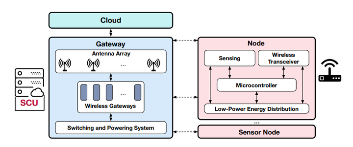
From the energy efficiency point of view, Nodes may rely on battery or solar harvested energy. Therefore, it is essential to minimize energy consumption to reduce the cost of an energy harvesting system. Relying on renewable energy offers the additional benefit of reducing maintenance costs by eliminating the need to replace batteries frequently. From the scalability point of view, the system must be easy to extend without deploying a large number of Gateways.
Compared to the other flood-monitoring projects, Flomosys will achieve scalability by keeping Node costs low and shifting more expensive hardware and internet requirements to the Gateway. Because dedicated GSM modules and expensive recurring cellular plans are not required, deploying tens or hundreds of Nodes will cost much less than full systems, therefore dropping the average cost per monitored site for every Node installed and keeping total recurring costs very low. Also, the long communication range of the Nodes will reduce the number of Gateways required to cover an area. Last but not least, secure communication between Nodes and Gateways is essential. In this regard, authenticity is necessary to ensure a valid Node has generated the data received by a Gateway. Also, integrity is required to ensure the received data is tamper-free. Confidentiality is not essential because the data sampled by Nodes are not confidential.
Energy efficiency is a major concern for Flomosys. Additionally, energy efficiency is directly related to reliability concerns for the system. As Flomosys is designed for remote locations, often without electricity, it must be feasible to power the system with renewable energy. For example, it should not drain a battery faster than the recharging rate of an inexpensive COTS solar panel. However, given the many variables involved in calculating the expected energy harvesting rate from renewable sources, we have chosen to determine how long the system can survive powered by a 2400 mAh battery. The energy cost of each operation, including data sample collection, packet encryption, and wireless transmission, has been recorded and analyzed using the EMPIOT board. These measurements, as well as sleep power consumption, were also measured and verified using a high-precision digital multi-meter (Tektronix 7510).
To determine the theoretical lifetime of Flomosys with different average retries and wireless configurations, we have used the appropriate equation. The most reliable transmission results were observed with a CR of 4/7 and SF of 1024. However, as the distance between the Node and the Gateway reduces, a lower SF and CR may be acceptable. For this reason, two graphs have been generated which display the theoretical system lifetime for various retransmission rates with the CR and SF used at the longest distance (9 miles), and the theoretical system lifetime for various retransmission rates with lower SF and CR values, to show maximum lifetime. Finally, it is important to note these figures do not take into account battery self-discharge, which will significantly lower the system’s lifetime. The particular battery we use has a lifespan of 5 years. Consequently, the system remains operational for a substantial period before any key component replacement is necessary. Ultimately, the longevity of this component reduces the need for frequent maintenance.
Multiple competing solutions offer comparable features and use similar methods to monitor flood zones. Unlike the other solutions, Flomosys can be built inexpensively with off-the-shelf components and scales across vast territories at a low cost per Node. In the worst case, Flomosys can continuously report data over several miles for 100 days using a 2400 mAh battery, or for 2.8 years under perfect conditions, marking it as very low-power and energy efficient. HMENC, the low-power encryption algorithm, secures all data sent between Nodes and Gateways, and the protocol supports adding new message types in case additional modules need to be added to the board. Together, these properties ensure Flomosys is a low-cost, low-power, secure, scalable, reliable, and extensible flood monitoring solution.


 Loading ...